Attached: 1 image
The great map myth was incredibly unfair to the 'mother continent': This is the true size of #Africa
https://www.green.earth/blog/true-size-map-africa
I wish we would stop stretching land masses and start stretching oceans in basic maps. We don’t need the Mercator for naval navigation in our day to day lives, but knowing the real size of Russia and Africa would affect our basic view of the world.
If Africa was the same continent as Asia, it should be easy to walk across.
But you literally can’t. The only connections are a freeway bridge (currently closed), a railway bridge, a road tunnel and ferries. And geologically, an ocean is in the process of opening up in between.
As for Europe, it doesn’t even have its own continental plate.
It’s less of a continent than India.
That butterfly one looks sick, I’m not a fan of the overplayed “world map in a cool material” wall-art but this one might get a pass depending on the execution.
There are several projections that follow this butterfly style. Still haven’t decided which one I want on my wall. There’s a local laser cutting company that definitely could make one out of plywood. I think it would look awesome.
Absolutely. In a sailing context, it would totally make sense to have a digital map like that. I don’t know if professional navigators actually do that though. Maybe they have some even more obscure projection that has some unique benefits that fit a particular niche.
Specifically, radio operators like them - with a directional antenna, it matters which direction goes from Canada to Australia the fastest, and if your station is fixed it can even be a paper map.
I don’t know what sailing yachts would use. Probably a close-up map that’s nearly flat anyway, since surf, wind direction and local obstacles are the main consideration. In commercial or military sailing, it’s entirely possible normal navigation just takes place automatically and digitally at this point. Sextant, compass and Mercator still exist as a backup, though!
In a military context, you absolutely need to have robust backups. If your ship gets badly damaged you better be familiar with star charts and sextants.
Oh, and that radio operator thing makes a lot of sense too.


I wish we would stop stretching land masses and start stretching oceans in basic maps. We don’t need the Mercator for naval navigation in our day to day lives, but knowing the real size of Russia and Africa would affect our basic view of the world.
Here you go:

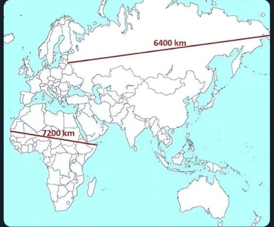
In which Asia’s and Africa’s claim to “continent” status looks suddenly shaky, and Europe’s completely laughable.
If Africa was the same continent as Asia, it should be easy to walk across.
But you literally can’t. The only connections are a freeway bridge (currently closed), a railway bridge, a road tunnel and ferries. And geologically, an ocean is in the process of opening up in between.
As for Europe, it doesn’t even have its own continental plate.
It’s less of a continent than India.
Perfection.
If stretching is ok, then why not go all the way.
If you dislike stretching, you can always cut instead. That’s why we also have a series of octahedral butterfly maps.
If that’s not polyhedral enough, you could try the Dymaxion projection instead.
That butterfly one looks sick, I’m not a fan of the overplayed “world map in a cool material” wall-art but this one might get a pass depending on the execution.
There are several projections that follow this butterfly style. Still haven’t decided which one I want on my wall. There’s a local laser cutting company that definitely could make one out of plywood. I think it would look awesome.
Actually, azimuthal equidistant is unironically useful if it centers on you.
Absolutely. In a sailing context, it would totally make sense to have a digital map like that. I don’t know if professional navigators actually do that though. Maybe they have some even more obscure projection that has some unique benefits that fit a particular niche.
Specifically, radio operators like them - with a directional antenna, it matters which direction goes from Canada to Australia the fastest, and if your station is fixed it can even be a paper map.
I don’t know what sailing yachts would use. Probably a close-up map that’s nearly flat anyway, since surf, wind direction and local obstacles are the main consideration. In commercial or military sailing, it’s entirely possible normal navigation just takes place automatically and digitally at this point. Sextant, compass and Mercator still exist as a backup, though!
In a military context, you absolutely need to have robust backups. If your ship gets badly damaged you better be familiar with star charts and sextants.
Oh, and that radio operator thing makes a lot of sense too.
Thanks, I hate you.