

They not only screwed up their continent borders, but they forgot the continent of Antarctica. There are tons of researchers who spend months (maybe years?) living there while working. It’s extremely low, but there’s a non-zero chance someone could be born there.
Looks like there have officially only ever been 11 Antarctic births, and none since 1985. While you’re right that it’s likely non-zero, it’s also probably zero.
it’s also probably zero.
That’s not how math works.
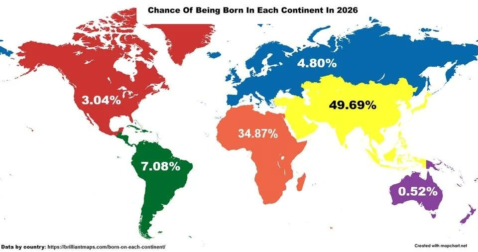
Siberia is not part of Europe you weirdos.
One could say the map simply counted transcontinental countries as where the majority of the population lives, but French Guiana isn’t colored like Europe.
Also interesting that the southern border of Mexico is apparently the border between North and South America.
That’s an odd way to divide it up. Without Mexico, the US would be much, much lower. Every continent map shows Russia as part of Asia.
Of course the europe-asia border is wrong, but the south america -north america border is wrong as well. It should be where Panama is.
I see a lot of US Americans think that north America only has 3 countries. That’s false.
Trump’s delusions about Greenland seem to be contagious to whoever color-coded this map.
I see a lot of US Americans think that north America only has 3 countries. That’s false.
Three countries is what I was taught in school in the 80s and 90s. And that the Americas are 3 continents; North, Central, and South America.
What was the reasoning back then for singling out central America?
Damn, Ukraine really went crazy with its 2026 counteroffensive.
From the Sea to the Sea to the Sea to the Sea to the Sea
Wow, Asia’s still ahead, I wouldn’t have guessed that.


